

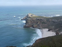
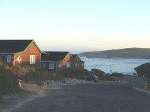
The view of Fish Hoek from 750 metres above sea level - looking east towards False Bay - click onto the image for a higher resolution (Photograph : John Ryland).
It was a pleasure to meet up with UK dxer John Ryland for the first time in April this year. Together with Vince Stevens, the three of us managed an evening mini dxpedition at the Fish Hoek sports fields. Despite the mediocre reception conditions, John enjoyed the opportunity to listen to a few good mediumwave signal peaks from Western Australia.
John kindly sent me an interesting aerial photograph which he took during a helicopter flight above the Cape Peninsula. The Fish Hoek sportsfields can be seen in the foreground. By good fortune, the gravel road to the left of the sports fields is aligned towards Australia and convenient for a quick set-up of the BOG (Beverage On Ground) antenna.


2 comments:
Good photo of our Valley,I have room to run a BOG from my QTH, East West as Parkland behind me. Must give it a go in the Summer
Hi John
An east-west BOG would certainly be worth setting up - especially for the summer dawn enhancement / pre sunrise T-A mediumwave reception from North America.
73
Gary
Post a Comment